

-30%


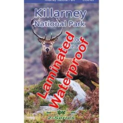


Killarney National Park Waterproof Map
Original price was: $24.00.$16.80Current price is: $16.80.
- SSL encryption, absolutely safe shopping
- Satisfaction Guaranteed
- Safe Transactions, Happy Customers
- Your satisfaction is 100% guaranteed.

Definitive detailed map at 1:20,000 scale covering Killarney National Park and Mangerton Mountain. The map extends from the Gap of Dunloe to Glenflesk. Includes Killarney town, National Park, Purple & Mangerton Mountains. Produced to our 25Series standard, this general topographic map has a 5 metre contour interval for fine navigation. Signposted walking trails are depicted. Detailed topographic map with many placenames and heritage sites. Printed on good quality Progeo 90gsm map paper. The map sheet measures 1125mm x 820mm, covering 350 sq kilometres and is folded down to 125mm x 205mm.
Be the first to review “Killarney National Park Waterproof Map”
Related products
-30%

Original price was: $21.00.$14.70Current price is: $14.70.
-30%
Accessories
Original price was: $95.00.$66.50Current price is: $66.50.
-46%


Jackets & Vests
Original price was: $180.00.$96.99Current price is: $96.99.
-30%

Accessories
Original price was: $12.00.$8.40Current price is: $8.40.
-30%


Original price was: $65.00.$45.50Current price is: $45.50.
-30%


Accessories
Original price was: $50.00.$35.00Current price is: $35.00.
-30%


Original price was: $65.00.$45.50Current price is: $45.50.
-30%


Accessories
Original price was: $45.00.$31.50Current price is: $31.50.
Reviews
There are no reviews yet.